Quick Answer
How was Lanzarote formed? By repeated volcanic eruptions beneath the Atlantic Ocean. Lanzarote formed gradually over millions of years rather than in one single event. Its first major above-water volcanic formations began developing around 15 million years ago. The most significant eruptions in recorded history ran from 1730 to 1736, transforming roughly a quarter of the island and creating most of what you see in Timanfaya today. The most recent recorded eruption was in 1824. The island is not currently erupting but remains part of an active volcanic region.
Why Is Lanzarote Volcanic?
Lanzarote belongs to the Canary Islands, a volcanic archipelago in the Atlantic Ocean off the north-west coast of Africa. The islands sit within the African tectonic plate. Over millions of years, molten rock rose towards the surface and when it erupted it became lava, which cooled and hardened into volcanic rock. Successive eruptions built Lanzarote gradually rather than one enormous event.
The island's oldest major above-water formations are Los Ajaches in the south and Famara in the north-west. These ancient mountain areas have been reshaped by millions of years of erosion, which is why they look so different from Timanfaya's younger volcanic cones. When you drive past the Famara cliffs or through the Ajaches, you are looking at a much older Lanzarote than the one around Timanfaya.
The Timanfaya Eruptions: Six Years That Changed the Island
On 1 September 1730, an eruption began near Timanfaya. It was the beginning of a volcanic episode that continued until 1736, with lava emerging from multiple openings across western Lanzarote.
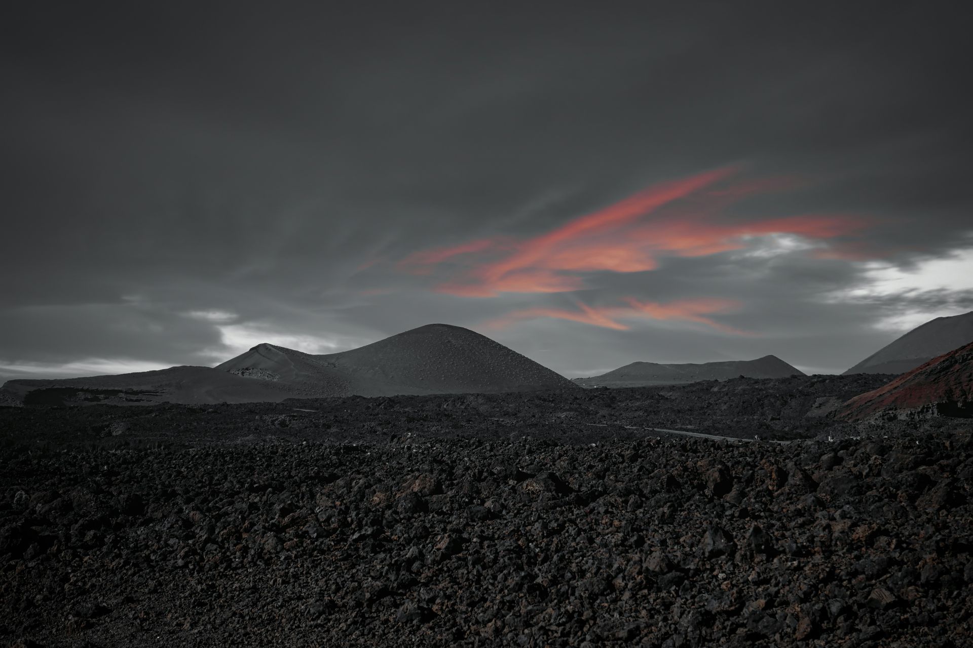
The eruptions affected approximately one quarter of the island. They covered farmland, destroyed settlements and forced residents to abandon their homes. Some of the black lava fields you see in Timanfaya cover land where people once lived, farmed and raised families. That is worth sitting with for a moment before you take the photograph.
The dry climate has helped preserve many of Timanfaya's volcanic formations, allowing visitors to see a landscape that still closely reflects the historic eruptions.
When Did Lanzarote Last Erupt?
The most recent recorded eruption occurred in 1824, when three volcanic centres became active: Tao, Nuevo del Fuego (Chinero) and Tinguatón. The activity lasted from July until October 1824. No volcanic eruption has been recorded on Lanzarote since then.
The island remains part of an active volcanic region and future volcanic activity cannot be ruled out. Parts of Timanfaya retain substantial geothermal heat beneath the surface. This heat is responsible for the demonstrations at Islote de Hilario, but it is not, on its own, evidence of an impending eruption.
Why Is Timanfaya Still Hot?
At Islote de Hilario inside Timanfaya, water poured into a ground opening produces a burst of steam. Natural underground heat is also used for cooking at El Diablo Restaurant. Parts of Timanfaya retain intense underground heat associated with the island's volcanic system.
The geothermal demonstrations are a reminder of Lanzarote's volcanic origins, not a sign that an eruption is currently taking place.
How the Volcanoes Created Caves and Vineyards
Cueva de los Verdes and Jameos del Agua
When flowing lava cools on the outside while molten rock continues moving inside, it can leave an underground passage called a lava tube. An eruption of Volcán de la Corona in northern Lanzarote created the tunnel system that includes both Cueva de los Verdes and Jameos del Agua. Both attractions belong to the same volcanic formation and are separate from the historic Timanfaya eruptions. Most visitors do not realise they are different geological events.
La Geria: Farming on Volcanic Ash
After the historic eruptions, farmers adapted to land covered in volcanic ash and gravel. They planted vines in hollows dug through the volcanic material and built curved stone walls to protect them from the wind. The volcanic covering helps conserve moisture, making it possible to grow grapes in Lanzarote's dry climate.
Today La Geria's black vineyards are among the island's most distinctive landscapes and produce Malvasía Volcánica, the wine most closely associated with Lanzarote. The eruptions that destroyed a quarter of the island also, eventually, created one of its most interesting industries.
Best Places to See Lanzarote's Volcanic Landscape
Timanfaya National Park
The landscape created during the 1730 to 1736 eruptions, explored on the authorised Montañas del Fuego coach route. Visitors cannot freely drive or walk across the protected volcanic terrain so book tickets in advance online. Tickets are not sold at the entrance. The geothermal demonstrations at Islote de Hilario are included.
Volcán del Cuervo
Volcán del Cuervo, one of the Lanzarote volcanoes you can actually walk inside, is associated with the beginning of the 1730 eruptions, with a marked walking trail that allows you to enter the crater provided you stay on the designated path. One of the few places where you can walk inside a Lanzarote volcano rather than look at it from a coach window.
Cueva de los Verdes
The underground lava tunnel created by Volcán de la Corona. A guided walk through the tube shows how molten rock shaped the landscape beneath Lanzarote. Book in advance alongside Jameos del Agua if you want to see both.
Los Hervideros
Atlantic waves crashing against volcanic cliffs formed from historic lava flows. The sea has gradually eroded the rock, creating openings and channels through which the water surges. Worth stopping at on any south-west coastal route.
Stay on marked paths and designated viewing areas. Lanzarote's volcanic terrain is sharp and unstable and protected lava fields are easily damaged. This is not a rule that exists to be inconvenient.
Frequently Asked Questions
Is Lanzarote still volcanically active?
Lanzarote remains part of an active volcanic region, although the island is not currently erupting. Its most recent recorded eruption was in 1824 and future volcanic activity cannot be ruled out.
How old is Lanzarote?
Its first major above-water volcanic formations began developing around 15 million years ago, although its underwater volcanic foundations are older.
When did Lanzarote last erupt?
1824, involving volcanic centres at Tao, Nuevo del Fuego and Tinguatón. Activity ran from July to October that year.
Can you visit the volcanoes in Lanzarote?
Yes. The Lanzarote volcanoes you can visit include Timanfaya on its authorised visitor route and Volcán del Cuervo on a marked trail where you can enter the crater. Access restrictions vary between protected areas so check before you go.
Were Jameos del Agua and Cueva de los Verdes formed by Timanfaya?
No. Both belong to the lava-tube system created by Volcán de la Corona in northern Lanzarote, which is a separate geological formation from Timanfaya.
Are the volcanoes in Lanzarote dangerous?
Lanzarote is not currently experiencing a volcanic eruption. Its last recorded eruption occurred in 1824, although future volcanic activity cannot be ruled out. For visitors, a more immediate consideration is the volcanic terrain itself. Stay on marked trails and designated viewing areas, particularly around craters, steep slopes and protected lava fields.
To Wrap Up
Lanzarote's volcanic history is visible everywhere: in the ancient cliffs of Famara, the black lava fields of Timanfaya, the lava tubes of Cueva de los Verdes and the vineyards of La Geria. The island was not always this landscape. People lived where the lava fields are now. They adapted, rebuilt and found ways to farm volcanic ash.
Once you understand how the island was formed, even an ordinary drive through the volcanic landscape of Lanzarote becomes more interesting. The volcanic landscape Lanzarote has is not decoration. The black rocks are not a feature. They are the whole story.